Results


HD Quiz powered by harmonic design
#1. What will be the effect on the reading of an altimeter of an aircraft parked on the ground shortly before an active cold front passes?
As the cold air advances, it forces the warm air upwards causing the warm air to cool. The water vapour in the warm air mass, consequently, condenses, and clouds are created. The slope of the cold front boundary is steeper than that of the warm front, with a gradient of approximately one in fifty.
The unstable air just ahead of the cold front is, forced to rise vigorously. Causing pressure to reduce and altimeter reading increased
#2. In which approximate direction does the centre of a frontal depression move?
the whole of the polar front depression will move as the warm front and cold fronts move and will in fact narrow, as the cold front moves faster than the warm. The depression at the tip of the warm sector will move parallel to the isobars in the warm sector at a speed given by the distance between the first and second isobars.

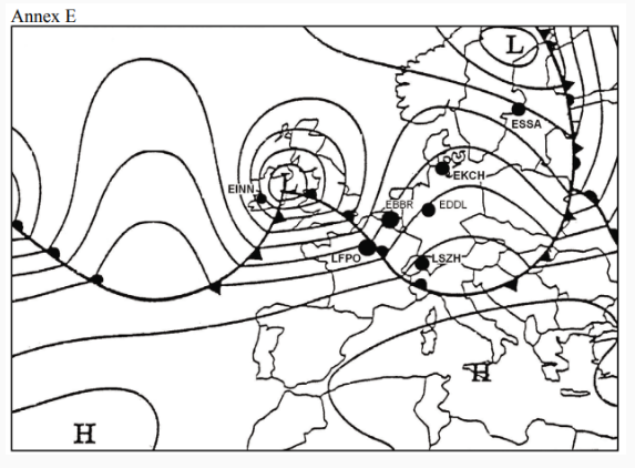
#3. The cold front is indicated with a number at position:
triangles,are the standard symbols denoting a cold front.
hence 4
semi-circular Are denoting warm front
#4. The main factor which contributes to the formation of very low clouds ahead of a warm front is the
Because the warm air is being forced upwards into lowering atmospheric pressure, the air expands and cools. Water vapour in the air, therefore, condenses, creating cloud along the frontal boundary. The cloud takes on a horizontal, layered appearance since the slope of the warm front is about one in one hundred and fifty, much shallower than the slope indicated in the diagram This layer-type cloud is called stratiform cloud.
#5. A squall line usually is most likely to be encountered
#6. When do cold occlusions occur most frequently in Europe?
#7. When do cold occlusions occur most frequently in Europe?
#8. The polar front is the boundary between:
#9. Which of the following is typical for the passage of a cold front in the summer ?
#10. The warm sector is indicated by letter:
#11. In which air mass are extremely low temperatures encountered?
#12. What characterizes a stationary front?
#13. What type of front / occlusion usually moves the fastest?
#14. What will be the effect on the reading of an altimeter of an aircraft parked on the ground during the period following the passage of an active cold front?
#15. Where does polar continental air originate?
#16. After passing at right angles through a very active cold front in the direction of the cold air, what will you encounter, in the northern hemisphere immediately after a marked change in temperature?
#17. In which of the following regions does polar maritime air originate?
#18. How do air masses move at a warm front?
#19. What types of cloud will you meet flying towards a warm front?

#20. (For this question use annex A) Refer to the diagram. Assuming the usual direction of movement, to which position will the polar frontal wave have moved?
#21. In which main direction does a polar front depression move?
#22. The front labeled “1” is a:
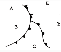
#23. How are the air masses distributed in a cold occlusion ?
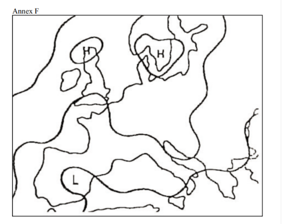
#24. (For this question use annex F) Which typical weather situation is shown on the weather chart? (Spacing of the isobars: 5 hPa)
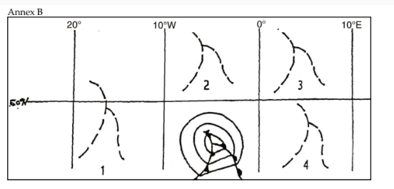
#25. (For this question use annex B) Refer to the diagram. Assuming the usual direction of movement, where will this polar frontal wave have moved?
#26. Where is the coldest air to be found, in an occlusion with cold front characteristics?
#27. What cloud cover is typical for a wide warm sector of a polar front depression over Central Europe in the summer ?
#28. A frontal depression passes through the airport. What form of precipitation do you expect?
#29. At the approach of a warm front (northern hemisphere) the wind direction changes from the surface up to the tropopause. The effect of this change is that the wind
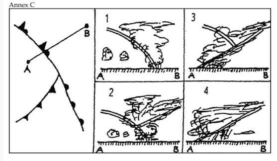
#30. (For this question use annex C) Which cross-section of air mass and cloud presentation is applicable to the straight line A-B?
#31. What is the surface visibility most likely to be, in a warm sector of tropical maritime air, during the summer?
#32. On an aerodrome, when a warm front is approaching
#33. During a cross-country flight at FL 50, you observe the following sequence of clouds: Nimbostratus, Altostratus, Cirrostratus, Cirrus. Which of the following are you most likely to encounter?
#34. How do you recognize a cold air pool?
#35. What is encountered during the summer, over land, in the centre of a cold air pool?
#36. Which of the following describes a warm occlusion?
#37. Thunderstorms can occur on a warm front if the
#38. What is the relative movement of the two air masses along a cold front?
#39. What type of precipitation would you expect at an active unstable cold front?
#40. Frontal depressions can be assumed to move in the direction of the 2000 feet wind
#41. Read this description: “After such a fine day, the ring around the moon was a bad sign yesterday evening for the weather today. And, sure enough, it is pouring down outside. The clouds are making an oppressively low ceiling of uniform grey; but at least it has become a little bit warmer.” Which of these weather phenomena is being described?
#42. What are the typical differences between the temperature and humidity between an air mass with its origin in the Azores and an air mass with its origin over northern Russia?
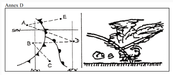
#43. (For this question use annex D) Examining the pictures, on which one of the tracks (dashed lines) is this cross-section to be expected?