Pressure

Results

-
Pressure
Pressure

HD Quiz powered by harmonic design

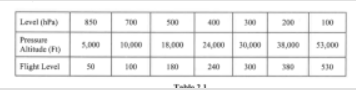
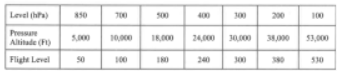
#1. The 850 hPa pressure level can vary in height. In temperate regions which of the following average heights is applicable?

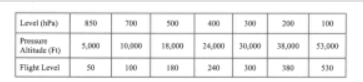
#2. Which constant pressure altitude chart is standard for 18,289 FT pressure level (FL 180)?

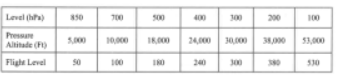
#3. If you are planning a flight at FL 170, which of these upper wind and temperature charts would be nearest your flight level?

#4. Which constant pressure altitude chart is standard for a 38,662 FT pressure level (FL 390)?

#5. The station pressure used in surface weather charts is

#6. Half the mass of the atmosphere is found in the first

#7. A 500 hPa pressure level can vary in height. In temperate regions which of the following average heights is applicable?

#8. Which constant pressure altitude chart is standard for a 4781 FT pressure level (FL50)?

#9. The QNH at an airfield located 200 metres above sea level is 1022 hPa. The air temperature is not available. What is the QFF?

#10. A 700 hPa pressure level can vary in height. In temperate regions which of the following average heights is applicable?

#11. When planning a flight at FL 60, which upper wind and temperature chart would be nearest your flight level?

#12. The QFF at an airfield located 400 metres above sea level is 1016 hPa. The air temperature is 10°C higher than a standard atmosphere. What is the QNH?

#13. Which of the following is true concerning atmospheric pressure?

#14. The upper wind and temperature chart of 250 hPa corresponds, in a standard atmosphere, to about

#15. What positions are connected by isobars on the surface weather chart?

#16. How would you characterise an air temperature of -30°C at the 300 hPa level over Western Europe?

#17. The QFF at an airfield in California located 69 meters below sea level is 1030 hPa. The air temperature is 10°C lower than a standard atmosphere. What is the QNH?

#18. What is the approximate vertical interval which is equal to a pressure change of 1 hPa at an altitude of 5500m?

#19. The greater the pressure gradient the

#20. When planning a flight at FL 110, which upper wind and temperature chart would be nearest your flight level?

#21. The QNH at an airfield in California located 69 meters below sea level is 1018 hPa. The air temperature is 10°C higher than a standard atmosphere. What is the QFF?

#22. The QNH at an airfield located 0 meters above sea level is 1022 hPa. The air temperature is not available. What is the QFF?

#23. In what hPa range is an upper weather chart for FL 340 situated?

#24. If you are flying at FL 100 in an air mass that is 10°C warmer than a standard atmosphere, what is the outside temperature likely to be?

#25. In the troposphere the decrease of pressure per 100 m increase in height

#26. The QFF at an airfield located 400 meters above sea level is 1016 hPa. The air temperature is 10°C lower than a standard atmosphere. What is the QNH?

#27. Isobars on a surface chart are lines of equal

#28. A 200 hPa pressure altitude level can vary in height. In temperate regions which of the following average heights is applicable?

#29. If you are planning a flight at FL 290, which of these upper wind and temperature charts would be nearest your flight level?

#30. A 300 hPa pressure level can vary in height. In temperate regions which of the following average heights is applicable?

#31. The QNH at an airfield located 200 metres above sea level is 1009 hPa. The air temperature is 10°C lower than a standard atmosphere. What is the QFF?

#32. Which constant pressure altitude chart is standard for a 30,065 FT pressure level (FL 300)?

#33. Which constant pressure altitude chart is standard for a 9,882 FT pressure level (FL 100)?

#34. The isobars drawn on a surface weather chart represent lines of equal pressure

#35. If the pressure surfaces bulge upwards in all levels then the pressure system is a

Finish
Pressure
Scroll to top